Back to Art's Hiking Maps Main Page
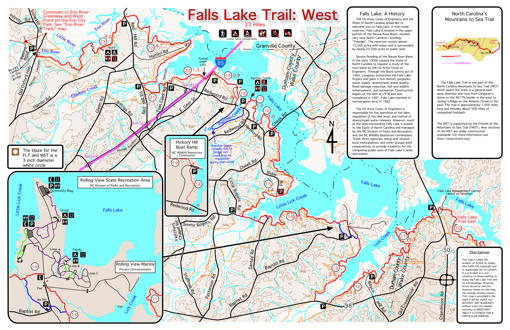
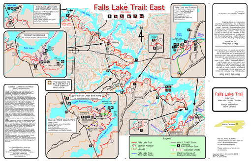
The Falls Lake Trail runs approximately 60 miles through Durham and Wake Counties in North Carolina following the south bank of the Eno River and the south shore of Falls Lake. The western end is at Old Oxford Highway near Penny's Bend on the Eno River in Durham. The eastern end is at Falls Lake Dam and Tailrace on Falls of Neuse Road north of Raleigh. The Falls Lake Trail is part of North Carolina's Mountains to Sea Trail.
Reduced size images of both sides of the map are shown below. They are intentionally too small to be printed. For a variety of reasons, I am not distributing the map electronically.
The map is printed full-color double-sided on plain 11x17 in paper and folds to under 3x6 in for convenient carrying while hiking.
This map is printed using a Xerox Phaser 7500DN color laser printer. Unlike maps printed with inkjet printers, the colors won't bleed in humid weather.
To help defray expenses, this map is $1 to the hiking public by sending me a self-addressed stamped envelope (SASE). It will be printed on plain paper which cannot be gotten wet.
I can also print the map on Weatherproof Paper. Using this paper, the map can be soaked in water with no problem. It is much more durable in the long term. Because the paper is so expensive, to help cover my cost, I will request that you send $3 enclosed with your SASE.
For instructions on how to order, send an email to (click on this link) Art. One FLT map per address please. By arrangement, larger quantities are available to groups or organizations. For display purposes, I can print the map single-sided on two sheets of paper and not fold it, but this requires the map to be shipped rolled in a tube. Please email with your requirements.This is a companion map to my map of the Eno River Trails. The Eno River Trails are west of the Falls Lake Trail. You can get both maps with one SASE.
|
|
|